
|
|
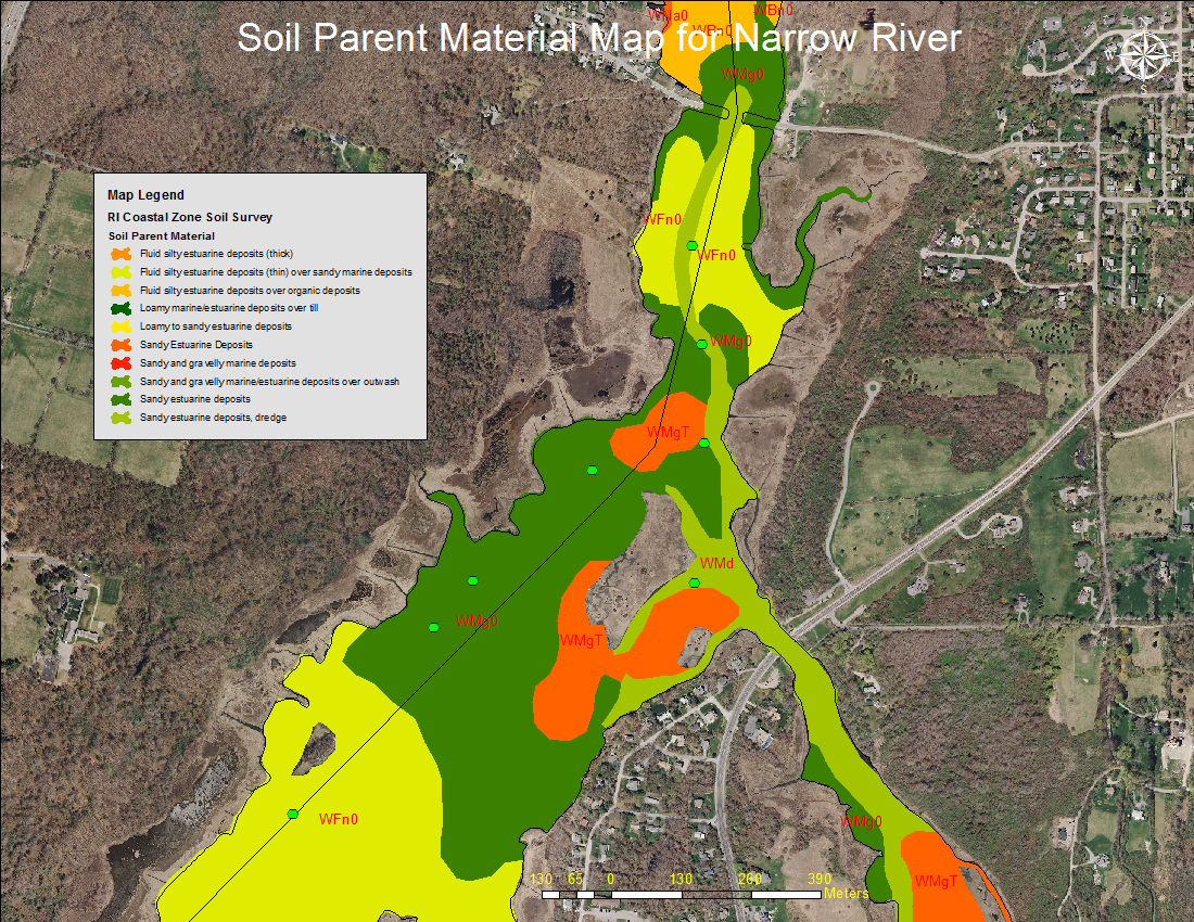
ResearchImpact of Dredging the Lower Narrow River on Circulation and Flushing in the Narrow RiverFinal Report prepared for the Rhode Island Coastal Resources Management Council by Authors Craig Swanson, Swanson Environmental Associates, and Malcolm Spaulding and Alex Shaw, Ocean Engineering, University of Rhode Island, 25 August 2016. Mapping the Soil and Sediment in Narrow RiverOne of the resources available in planning and evaluating marsh restoration projects in Narrow River is a survey of soils and sediment in the river completed in 2011 by the Mapping Partnership for Coastal Soils and Sediment (MapCoast), a collaborative effort headed up by the Rhode Island USDA-Natural Resources Conservation Service. The following are some links provided by Jim Turenne of NRCS that provide background on the project and access to the soil data: Why is Underwater Mapping Important? (pdf) describes the work of MapCoast. Watch a YouTube video of the soil and sediment coring in Narrow River. View a soil map of lower Narrow River. National Soil Map: The data from the survey have been integrated into the USDA's Natural Resources Conservation Service a national soil survey. An interactive map allows you to explore USDA-NCSS soil survey data for locations throughout most of the U.S. (This map application was developed by the California Soil Resource Lab at University of California at Davis and University of California Agriculture and Natural Resources in collaboration with the USDA Natural Resources Conservation Service.) Water Quality in the Lower Narrow RiverFor more than two decades NRPA has had a River Watch program that monitors the water quality at fourteen locations spanning the entire length of the Narrow River. Since the start of the program, elevated bacteria levels have been regularly observed at Mumford Brook and Mettatuxet Brook. Since 2001, elevated bacteria levels have also been observed at Middlebridge. In May of 2014, NRPA launch a two-year water quality program funded by U.S. Fish and Wildlife Service through the The Nature Conservancy to conduct supplemental water quality monitoring in the waters and streams of the John H. Chafee National Wildlife Refuge that reside within the towns of South Kingstown and Narragansett, Rhode Island to support saltmarsh and estuarine resiliency and restoration actions. View the final report to The Nature Conservancy and U.S. Fish and Wildlife Service. What Will Happen When the Real 100 Year Storm Hits?
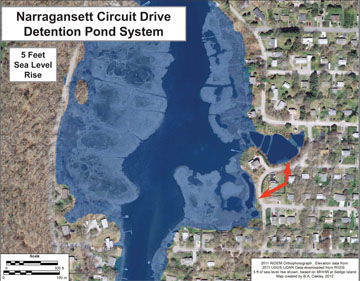
On October 30, 2012, the surge from Superstorm Sandy inundated the salt marshes and other areas along Narrow River, closed Middlebridge, and prompted many to refer to the event as a 100-year storm. But "Sandy was no 100-year storm. Rhode Island only received a glancing blow." So said coastal geologist Jon Boothroyd at the 2013 NRPA Annual Meeting on October 3 when he presented The Pettaquamscutt Estuary: Climate Change. Jon went on to illustrate how a storm of the magnitude of the 1938 Hurricane (which was a 100-year storm) would cause far more significant flooding. Starting with a primer on the geology of the watershed, Jon used aerial photographs and inundation maps to show the impact of Sandy and earlier storms on the river and the Rhode Island coast. He then discussed how future coastal storms and sea level rise will combine to cause even greater flooding than Sandy. The map above from Pettaquamscutt Estuary: Climate Changes shows predicted inundation at Circuit Drive in Narragansett from a five-foot sea-level rise. View all of the maps and photographs in Jon's keynote presentation.
Climate Change, Coastal Geologic Hazards and Sea-Level RiseOn Sunday, January 27, 2013 geologist and NRPA Vice President for Science Jon Boothroyd, Ph.D. presented "Climate Change, Coastal Geologic Hazards and Sea-Level Rise: Some Rhode Island Strategies" as part of the On Pettaquamscutt speaker series sponsored by NRPA, Friends of Canonchet Farm and South County Museum. Jon, who is a URI Research Professor Emeritus and the R.I. Sate Geologist, discussed what is happening to our coastline and the Narrow River Watershed and what we can do to adjust to the changes. Click the link below to view Jon's presentation: What's that Smell? Narrow River Overturn October 2007Some unusual things happened on Narrow River in the fall of 2007. It all began on Friday, October 12. The URI Women’s Crew Team noticed a strange milky color and an unpleasant smell in the Narrow River by their dock. The next day Dick Lee noticed big changes in the river while boating in the Upper Pond. What was happening to the usually quiet Narrow River? Click the link below for an explanation of why the river "overturned," or ventilated in October 2007, plus updates on the partial overturns since then: Water Quality, a Twenty Year RecordThe featured presentation at the NRPA Annual Meeting on October 4, 2012 was a report on the 20 years of water quality data collected by the Narrow River Watershed Watch program in conjunction with URI Watershed Watch. Using a PowerPoint® slide show, Board members Dr. Veronica Berounsky and Annette DeSilva focused on testing for bacteria, specifically fecal coliforms, and nutrients, using nitrogen measurements as an example, at sites spanning the river to illustrate trends. The high levels of bacteria at Middlebridge generated significant discussion, especially with the purchase of the Eddy property discussed earlier in the evening. Click one of the links below to view and download the full presentation:
|
Remembering
Jon Boothroyd   and a new moon tide combined to raise waters in Narrow River into the parking lot at Middlebridge Marina and flood the marsh just south of Narrow River Kayaks. Photos by Rosemary Smith.")  Follow us
on Facebook  NRPA is a member of the R.I. Rivers Council and has served as the Designated Watershed Council for Narrow River since 2002. NRPA Endowment Fund offers planned giving options
Narrow River Notes
|
